Trails east of Fullerton Road (Squirrel, Beaver, Hawk) are currently closed until June 30th for the birthing and rearing period.
For your safety and that of the species that chose this place to give birth and raise their young.
The Ruiter Valley Land Trust offers a network of 30 kilometers of marked trails maintained by volunteers.
They allow the practice of environmentally friendly activities. Hiking, cross-country skiing and snowshoeing are practiced in certain designated areas.
The trails are divided into three main areas: Shepherd, Ruiter and Fullerton. In winter, the Shepherd area is reserved for hiking and snowshoeing. The trails are easy to intermediate level.
Please note that cross-country skiing is at an advanced level (Backcountry skiing on marked trails, but not mechanically traced or groomed). The route has a pronounced steep slop in several places.
The trails of the Land Trust’s also provide a link with the Missisquoi North Trail, which leaves from Mansonville, those of the Réserve naturelle des Montagnes-Vertes and those of the sentiers de l’Estrie.
Access to the trails is free. A donation from visitors, in the parking lot coin box or via the Internet, is appreciated and helps us to better maintain them.
If you are not familiar with our trails, we suggest you download the map or install the Ondago application on your cell phone. You will find the interactive map of the Land Trust’s trails under the name of Vallée Ruiter in Ondago.


Hiking Suggestions

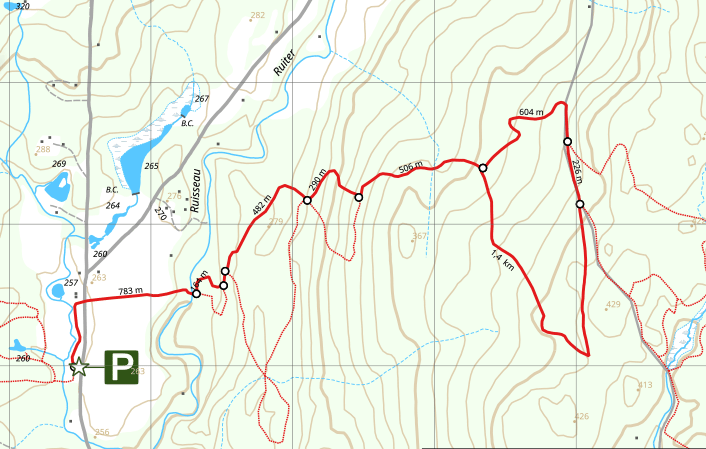
The Coyote Loop
The proposed route starts at the parking lot on Ruiter Brook Road. The nearly 7 km route is done by taking the Moose Trail, eastward, and then joining the Coyote loop about two (2) kilometers further. The return trip is on the same trail.
Length : 6,7 km (Loop)
Duration : ± 3 hours
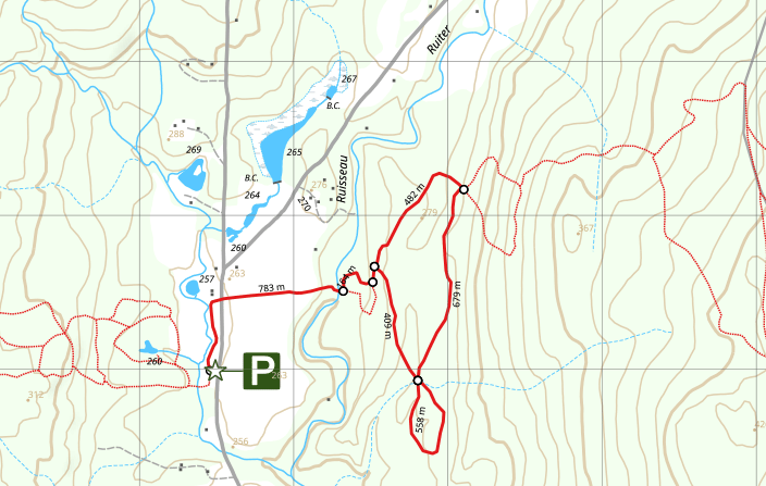
The Porcupine Loop
The proposed route starts at the parking lot on Ruiter Brook Road. The approximately 4 km route is done by taking the Moose Trail, eastward, and then joining the Porcupine Loop approximately one (1) kilometer further. The return trip is on the same trail.
Length : 4 km (Loop)
Duration : ± 2 hours
Hiking Suggestions
The Coyote Loop
The proposed route starts at the parking lot on Ruiter Brook Road. The nearly 7 km route is done by taking the Moose Trail, eastward, and then joining the Coyote loop about two (2) kilometers further. The return trip is on the same trail.
Length : 6,7 km (Loop)
Duration : ± 3 hours
The Porcupine Loop
The proposed route starts at the parking lot on Ruiter Brook Road. The approximately 4 km route is done by taking the Moose Trail, eastward, and then joining the Porcupine Loop approximately one (1) kilometer further. The return trip is on the same trail.
Length : 4 km (Loop)
Duration : ± 2 hours
Trail Etiquette
- Take Nothing With You But Your Memories.
Removal of plants or animals, living or dead is strictly forbidden. - Leave Nothing Behind But Your Footsteps.
Do not leave any litter or other physical evidence of your visit. - Respect Wildlife and Habitat.
Stay on the trails so that nature can flourish undisturbed! From mid-April to end of June is baby time in the woods. Signs and barriers are posted near vulnerable areas. During that time, do not enter the nursery areas. - Visitors must keep their dogs on leash.
You can bring your pet, but do not leave it at large.
- Respect the Private Property.
As some of the trails pass on private properties, stay on the trails. - In the Winter Time, the use of Snowshoesor Cross-country Skis is compulsory.
Snowshoers using cross-country ski trails must walk on each side of the trail in order not to damage ski tracks. - Motorized Vehicles, Bicycles, Fire and Camping are strictly prohibited.
- Our trails are not supervised.
We are not responsible for any damages or injuries you may suffer on our territory. We assume that you have read this notice.